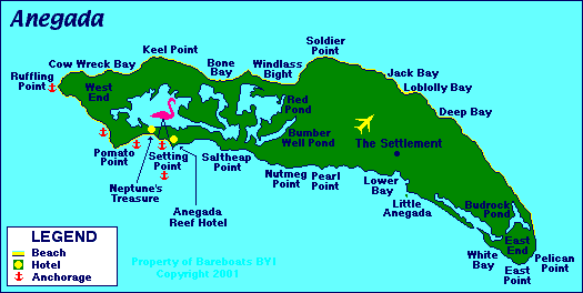
 Map Of Anegada
| Origin of Name: | Spanish for "Drowned Island". |
| Location: | Approximately 15 miles north of Virgin Gorda, 20 miles northeast of Tortola and about 93 miles east of Fajardo, Puerto Rico. |
| Description: |
This Coral island is approximately 10 miles long and 3 miles wide at the widest point and is the 2nd largest in the BVI chain. It is also basically flat and some of it is actually below sea level.
Approximately half the island is covered by wetlands including freshwater ponds, mangrove wetlands, and no less than 7, interconnected salt marshes and salt ponds. The island's claim to fame is the 9.3 mile long barrier reef that lies just north of the island, protecting the shoreline. It is the second largest barrier reef in the Caribbean. The famous Horseshoe Reef trails off the south east end of the island and is a fisheries protected area. Sadly, that has not stopped fishermen from fishing on the reef as the government doesn't seem to have any method of enforcement in this very remote area. |
| Population: | Approximately 225 to 250 (estimate only) |
| Main Town or Village: | The Settlement |
| Maximum elevation: | 28' to 36' above sea level ... depending upon which geological survey map you use. |
| Land Mass: | Approximately 15 square miles - About 10 miles long and 2 miles wide at the widest point. |
| Main industry: | Fishing and tourism. |