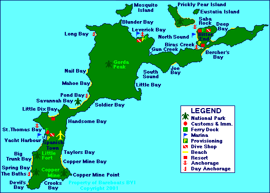
| Origin of Name: | Virgin Gorda is Spanish for "Fat Virgin". |
| Location: | Approximately 85 miles east of Fajardo, Puerto Rico. |
| Description: |
Volcanic island which is the 3rd largest largest in the British Virgin Islands chain. The island is approximately 10 miles long and 2 miles wide at the widest point. The northern part of the island is distinguished by its high rolling hills, winding (steep) roads, and a handful of small villages.
The southern part of the island is relatively flat by comparison to the north. Large granite boulders (some as large as 40 feet in circumference) can be found along the hillsides and the western coastline from just south of Spanish Town to Coppermine Point. The beaches are nothing short of exquisite! |
| Population: | Approximately 4,000 (estimate only) |
| Main Town or Village: | Spanish Town - also known as the Valley |
| Maximum elevation: |
Gorda Peak - 1,359' above sea level
Map E803 (D.O.S. 346) BVI 5 - Virgin Gorda |
| Land Mass: | Approximately 8.5 square miles. The island is about 12 miles long between Stoney Bay and Pajeros Point and just under 4 miles wide at the widest point between Mountain Point and South Sound Bluff. Measurements taken from map noted above. |
| Main industry: | Tourism. |
| National Parks: |
|
| Marinas offering overnight docking: |