
| Origin of Name: | Jost Van Dyke was likely named for a Dutch privateer named Joost Van Dyk. |
| Location: | Approximately 60 miles east of Fajardo, Puerto Rico. |
| Description: |
Yet another volcanic island which is the smallest of the 4 main islands.
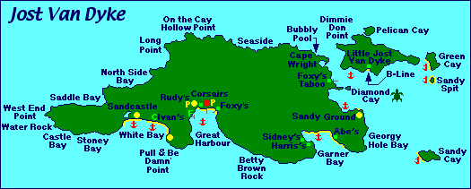
This is a quiet island with little infrastructure to speak of other than a few main roads, a church, a primary school, an ice house, a small but well stocked store for provisioning, several restaurants, a small selection of hotels and villas for rent. The island only got electricity in the 1990's. Before then, people used generators and kerosene lamps. White Bay Beach is one of the most lovely beaches in the BVI and is a popular daytrip destination for visitors from the U.S. Virgin Islands and the charter yacht community. In recent years, the Bubbly Pool has become quite popular. |
| Population: | Somewhere between 225 to 300 (estimate only) |
| Main Town or Village: | Great Harbour |
| Maximum elevation: | Majohnny Hill - 1,370' above sea level |
| Land Mass: | Approximately 8 square miles. |
| Main industry: | Tourism and fishing. |