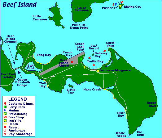
Located at the eastern tip of
Tortola and joined by the Queen Elizabeth bridge, Beef Island is home to the
Terrence B. Lettsome International Airport (EIS), the main airport for the British Virgin Islands. There are currently no direct international flights to the BVI. Travelers fly into one of the major Caribbean hubs such as Puerto Rico, Antigua, St. Martin or St. Thomas to board connecting flights to this airport.
You'll find 29 mooring balls in
Trellis Bay. Pay mooring fees at
De Loose Mongoose.
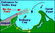
Round the cardinal buoy at Sprat Rock, stay between the yellow flashing markers and 2 green channel markers. Although it may not appear to be deep enough, the minimum depth is 12' in this area.
Yachts with masts exceeding 50' must request permission to enter Trellis Bay. Call the Civil Aviation Department on VHF Channel 16.
Trellis Bay Entrance: The
no go zone is clearly marked by a series of 8, yellow flashing markers. Vessels not exceeding 10' in height may traverse the No Go Zone safely.
Facts & Stats about Beef Island:
| Origin of Name: |
In the early 1700's, a large cattle farm existed here. There's an interesting story about pirates on Bellamy Cay stealing cattle from the resident lady farmer ... once upon a time. |
| Location: |
Approximately 74 miles east of Fajardo, Puerto Rico. Connected to the eastern tip of Tortola by bridge. |
| Description: |
Volcanic island. |
| Population: |
No data available. |
| Main Town or Village: |
Trellis Bay. |
| Maximum elevation: |
Unknown at this time. I don't have that map! |
| Land Mass: |
Not known at this time. I'll have to do more research. |
| Main industry: |
Tourism and the airport. |

